Outback South Australia
Ancient mountains, open plains, glistening salt lakes
Outback South Australia covers about 80 % of the state's area, an area of nearly 800,000 square kilometres. Population? Less than 1,5 % of South Australians live in these remote regions. It is a harsh and dry land, nevertheless, the South Australian Outback surprises with grandeur and timeless beauty.
Huge areas of glistening salt lakes, stony deserts, rugged mountain
ranges, and the vast treeless Nullarbor plain are only a few highlights
that await you.
South Australia is my home away from home. I have explored many beautiful places, and always love to return.
Let me invite you to explore the diverse wonders of this fantastic country with me.
 Salt lake near Pimba in the far north of South Australia
Table of Content (TOC)
- Where is the South Australian Outback?
It is a vast area, with beautiful destinations - From Adelaide to Port Augusta & the Flinders Ranges
Routes through the Mid North, lovely valleys and stunning mountains - Famous tracks in the north east
The Birdsville, Oodnadatta And Strzelecki Tracks - Along the Stuart Highway & its byways to the Northern Territory
Salt lakes, opals, deserts - Eyre Highway & the lonely west
Gawler Ranges and Eyre peninsula - Look at the map on the bottom of this page to get an overview (right-click and open in a new tab/window for convenient planning)
Where exactly is the South Australian Outback?
Well, I don't say you will notice when you get there, this would be
rude :).
Actually, the South Australian Outback covers the entire north
of the state, that's why it is also referred to as the Far North.
The region on a line north of the Eyre Highway to Port
Augusta, and then along the Barrier Highway to Yunta, is considered Outback. On this website however, I might cover border regions as well.
Mid North, Port Augusta & Flinders Ranges
Let's start in Adelaide, South Australia's capital. For me it is the gateway to the Outback anyway. There are several routes to the north, which one is the best depends on where you want to go.
The Princes Highway is part of Highway 1 that goes all around
Australia. It is the shortest connection to Port Augusta, the
cross-roads of Australia. From here highways lead to Perth (west coast),
Sydney (east coast) and to Darwin in the north.
 Near Spalding - Mid North of South Australia
The Main North Road out of Adelaide, and further north the RM Williams Way,
are the straightest routes to the Flinders Ranges. It is a
leisurely drive through South Australia's Mid North which is, along with
the Eyre Peninsula, the main agriculture district of the state.
Now that doesn't look much like Outback, right? Wait, you'll be there soon!
Once you arrive in Hawker, the small town that is called the hub of the Flinders Ranges, you are on your way to the most famous Outback tracks.
But wait! Take your time to explore the stunning Flinders Ranges, which are indeed a stunning part of the South Australian Outback. You can travel
north within the Flinders, and then join the "Hawker to Leigh Creek
road" (B83) through one of the gorges. It is worth the detour.
 Aroona Dam near Leigh Creek
This is a perfect spot to relax and have a picnic.
Leigh Creek, with its huge open-cut coal mine, is/was the last town
of any size in South Australia's north east. You could stock up with food and
water here.
Since the coal mine in Leigh Creek closed in late 2015, the town lost its original purpose (to be a home for the mine workers and their families). So, the future of the government-owned town is in the air.
Leigh Creek is still an inhabited town, but don't rely on the full service the town offered in its heydays.
Famous tracks and deserts
The bitumen ends in Lyndhurst, 580km north of Adelaide. Now you really hit the dust of the Outback. The Strzelecki Track to Innamincka begins here, a route that takes you to Innamincka, and finally to the south west of Queensland.
From Lyndhurst it is roughly 80 km to Marree. The tiny township
offers you many relics from a glorious past as a railway town. As of winter 2019, the road to Marree is fully sealed. Did I
tell you Marree is my favourite Outback town?
From Marree you have the choice to travel along two famous tracks. The Birdsville Track takes you into the far south west of Outback Queensland and its stunning channel country.
 Old Ghan bridge along the Oodnadatta Track
Are you eager to learn about the history of the old Ghan railway line? Then you need to follow the Oodnadatta Track. This route leads you to the Stuart highway, the main road from Adelaide to Darwin.
Stuart Highway and byways
The Stuart Highway is the main south to north route through the centre
of Australia. The road divides the eastern & western parts of the
South Australian Outback. It's a long drive on this well-maintained
bitumen road from Port Augusta to Alice Springs (1225km) in the Northern
Territory, even longer up to Darwin (2720km)!
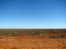
Is it boring? No way! There is so much Outback scenery to take in! See
the lakes on the map? These are usually dry salt lakes that glisten in
the sun. Smaller salt pans closer to the highway are always worth a
stop. Along with the red earth and the blue sky you have the chance to
take amazing photos.
The Outback's beauty is all about colours. Did I say that before? I think so.
 Animal tracks on a sand hill near Woomera
Around Woomera was the testing area for long range missiles in
the cold war. It is still a strategic defence post used for aerospace
activities. The rocket debris displayed in William Creek came from here.
Womera now welcomes visitors, however, a huge area west of the highway
is still restricted.
Roxby Downs, 83 km off the highway, is said to be the most modern
town in the Australian Outback. The town was built in 1987 to serve the
Olympic Dam mine. In my opinion, it is a rather artificial settlement.
There are some great sand dunes around Roxby, and the small opal mining
town of Andamooka is really worth a visit.
From Roxby Downs the Borefield road goes to the Oodnadatta Track.
 Big winch in Coober Pedy
The most interesting town in this part of Outback South Australia beyond doubt is Coober Pedy.
The opal capital of the world is a must see place. Interested in
Australian opal? Australia's national gemstone is a true beauty.
Outback South Australia - The lonely west
The areas west of the Stuart Highway / north of the Trans Australian Railway line are either Aboriginal land or belong to the Woomera prohibited area.
A few tracks constructed by Len Beadell in the 1950s and 60s are known
as the "bomb roads", as they were built to service the rocket test area.
These tracks are very remote, but they cover some of Australia's most
scenic desert country.
Don't be confused by the names of the tracks, they are all called highways, Anne Beadell Hwy, Connie Sue Hwy, Gary Hwy, named after Beadell's wife and children.
You have to be very well prepared and independent to travel these tracks.
Permits are required.
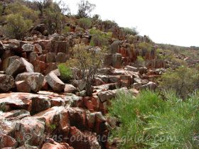
 The organ pipes in Gawler Ranges National Park
Between Glendambo (Stuart Highway) and Wudinna (Eyre Peninsula) is another area of rugged mountain ranges - the Gawler Ranges.
Ancient volcanic structures, called organ pipes and the vast,
glistening Lake Gairdner make this area a great destination for 4WD
enthusiasts.
Mount Ive Station is the only place that accommodates travellers in this beautiful wilderness.
 Nullarbor coastline at the great Australian Bight
This is an old image, therefore the quality is crap. But you get the idea of beauty, and the loneliness along the Nullarbor plain and Great Australian Bight.
The south western end of Outback South Australia is covered by the Nullarbor Plain,
the treeless plain, that stretches over 1200 km into Western Australia.
The Eyre Highway runs close to the coast, and you can see some
spectacular scenery.
The cliffs of the Great Australian Bight are amazing. The power of the sea is immense. It is as if the southern ocean would eat up the Australian continent.
Road map of South Australia

I hope you enjoyed this introduction to the South Australian Outback. Wherever you go, take care, and have a wonderful time.
Explore the stunning regions of Outback South Australia

Get an overview of the South Australian Outback regions. Get help to plan your journey along famous Outback tracks. Discover huge salt lakes and ancient mountain ranges.

The Oodnadatta Track is the most historic track in Outback South Australia. The route follows an ancient trail used by Aborigines, the Overland Telegraph and the Ghan railway

This route is one of the icons in the eastern Australian Outback. Read about the history, highlights, track conditions and the Cooper Creek ferry status.

The rugged mountain range is one of the oldest landscapes in the world. Get facts to plan a visit, enjoy the highlights of this spectacular destination.
The Gawler Ranges are a beautiful wilderness area. A perfect destination for 4WD adventures and exploring stunning nature.
This is an epic journey of more than 3000 km across the Australian Outback. Find out about highlights and facilities along the route.
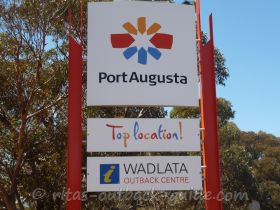
Port Augusta is called the cross-roads of Australia, and the gateway to the Flinders Ranges & the Outback.
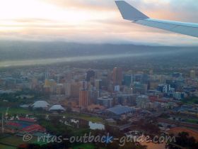
Discover beautiful Adelaide attractions, the capital city is the gateway to the Australian Outback.
South Australian Stories and Photos

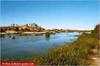
Morgan on the mighty Murray River
Morgan in South Australian was established in 1878 and quickly became Australia's busiest inland port during the bustling river trade of the early 1900s. …
Birdsville Track with a caravan
Hi Rita, Lyn and myself are planning a trip to the Birdsville races travelling up the Birdsville track.
My question is, is it suitable to tow a caravan …
The articles below help you to plan your journey


- Home ›
- South Australian Outback Overview
Travel Advice during Sars-CoV-2 Outbreak

Do you plan to travel to, or within Australia? Restrictions apply due to the Covid-19 pandemic.
Please click here for the latest travel advice from the Australian Government.
Don't miss these popular articles


Connect And Follow Our Tracks
Please join me at Facebook & Twitter
![]()
![]()
![]()
![]()
Legal Stuff
ALL RIGHTS RESERVED